
New homes and public open space in
Honeybourne
The Site
The site is located east of Buckle Street and north of the railway line in Honeybourne. Covering 13.14 hectares, the site is currently pastoral land forming part of Grove Farm. The site is not located in the Green Belt.
Design
A Design and Access Statement (DAS) will be submitted as part of the planning application and will present a high-level overview of the local character of Honeybourne and set out aspirations for the overall design of the proposals. Subject to discussions with officers at Wychavon District Council, any future reserved matters planning application, which will be prepared in accordance with local policies, will focus on the materials, details and character.
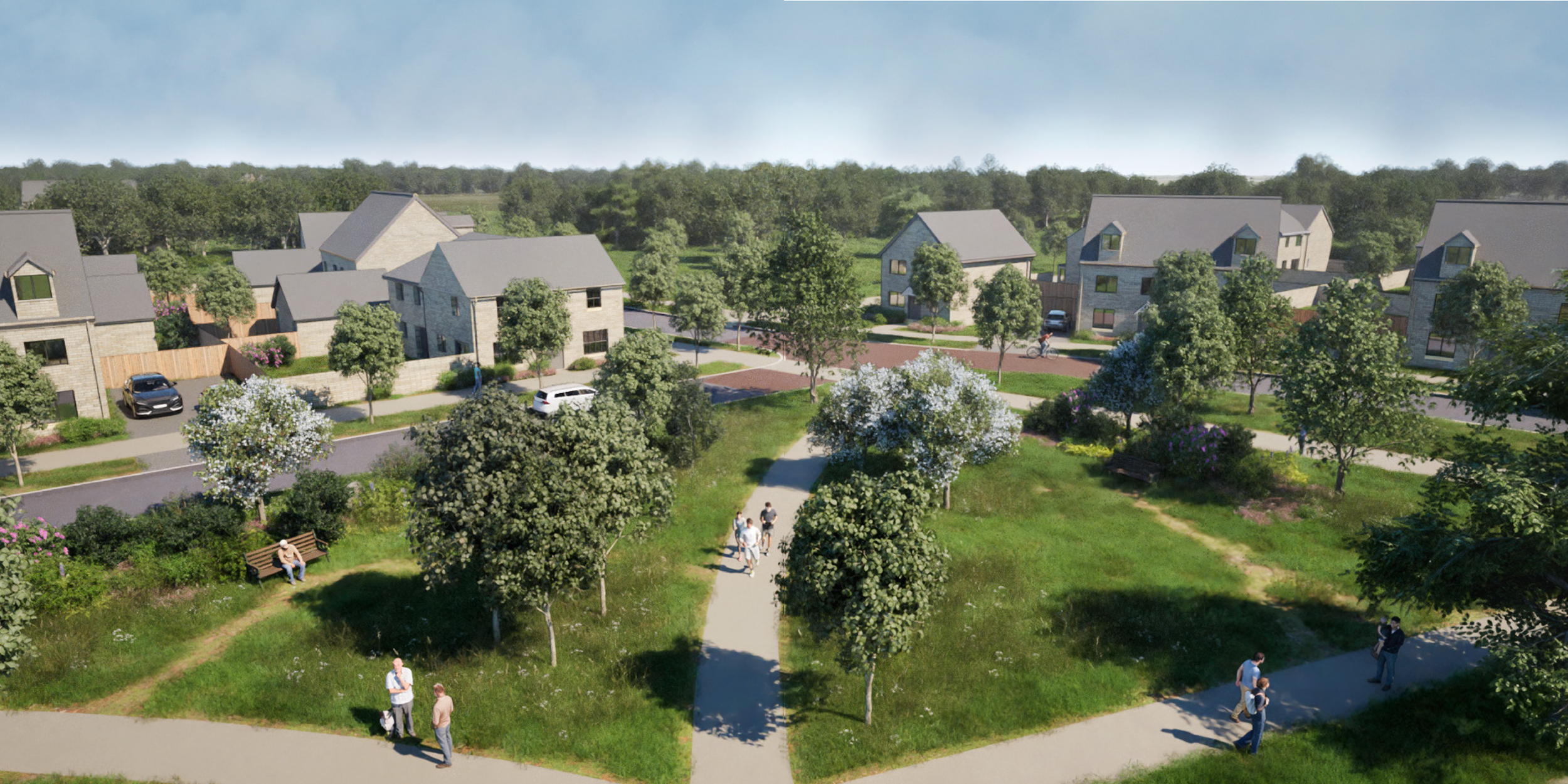
The proposed homes will include a mix of sizes, from 1-bedroom to 4-bedroom homes and will predominantly be up to 2 storeys in height, with the potential for some 2.5 storey homes in key locations as focal points and to add variety to the roofscape.
Over half of the entire site will be delivered as public open space, including a network of recreational walking routes, play areas (with ‘play-on-the-way') and additional planting. This will create a biodiverse and landscaped community asset, which will be enjoyed by new and existing residents alike.
Illustrative masterplan - click to enlarge
Transport and Access
Access to the site for vehicles is proposed via the existing junction for Grove Farm on Buckle Street, on the western edge of the site. The access will be designed to accommodate all necessary vehicle types and will include measures to support safe and convenient movement for pedestrians and cyclists.
Pedestrian access to and from the site will be delivered via Buckle Street, where a new footway will be provided. This footway will connect into the existing pedestrian infrastructure along Buckle Street, ensuring safe and convenient access for future users and providing a safe route for pedestrians to access local services.
The site also facilitates easy onward connections via public transport. Honeybourne railway station is approximately an 8-minute walk and two-minute cycle from the centre of the site. The station provides roughly hourly services in both directions, serving Evesham, Worcester, Oxford and London. The 553 bus route currently runs along Buckle Street with a morning service providing public transport access to services and further onward connections in Evesham.
As part of the planning application, we will submit a Transport Assessment which assesses the impact of the development on the local highway network. This exercise will use the nationally recognised TRICS database and Census data to accurately forecast and distribute traffic on key local routes and Honeybourne more widely.
Measures, including financial contributions to local infrastructure, will be put in place to mitigate the impact on local junctions, supporting and promoting the use of active and sustainable travel and limiting the impact of vehicle traffic.
Drainage
The site is in Flood Zone 1 meaning that it is within an area with the lowest probability of flooding at less than 0.1% each year.
As part of the drainage strategy covering the site, the proposals include an attenuation pond, swales and a pumping station to manage surface water and drainage risks. These features have been sensitively incorporated into the design within the public open space and to support the enhancement of local biodiversity.
A comprehensive drainage strategy utilising sustainable drainage systems (SuDS) will ensure that surface water falling on developed areas is captured, treated and attenuated on site before being discharged at a controlled rate which is set to ensure there is no increased flood risk on or off site.
Environment
The new homes will be designed to achieve the Future Homes Standard 2025, which will ensure they are all-electric, with high levels of fabric efficiency and powered by renewables. This will reduce carbon and energy bills for the residents, whilst also having a positive environmental impact. A significant proportion of the energy demand to power the homes will come from renewable sources, such as solar PV panels.
The Site is dominated by agricultural fields of low ecological value, including modified grassland and arable habitats. In the areas with higher value, which includes a network of hedgerows and mature trees bounding the fields and a ditch in the south-east, the design has retained these features wherever possible.
There are large areas of open space to create new valuable habitats including wildflower grassland meadows, native scrub, and species rich hedgerow planting with opportunities for new wildlife ponds. These features will provide a positive contribution to achieving a net gain in Biodiversity on site.
For example, the hedgerows are buffered from the development for bats, and nesting birds. The scheme allows for the additional creation of new green corridors with native species, rich hedgerow and native scrub planting to maintain and improve connectivity for wildlife across the wider landscape.